
Glory Hole Watch 2024 (4/21/24)
An Anticlimactic Climax, but possibly a new record!
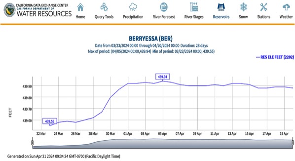
Less than a half inch of rain has fallen at Monticello Dam from the latest "storms" bringing the season total to 27.3 inches. This is about the average for the year. The lake levels remain basically flat. Glory Hole has not officially "spilled" and it is definitely not "flowing". The small amount of water actually lapping over the lip is actually too small to measure and is not officially considered a "flow".
But from a practical point of view Lake Berryessa is full, and this summer season will be great at the lake. Lake Berryessa and Glory Hole may have, if no major storms yet appear, set a new historical record, though an odd one.
This season will be the highest the lake level has ever reached without officially going over the Glory Hole spillway!
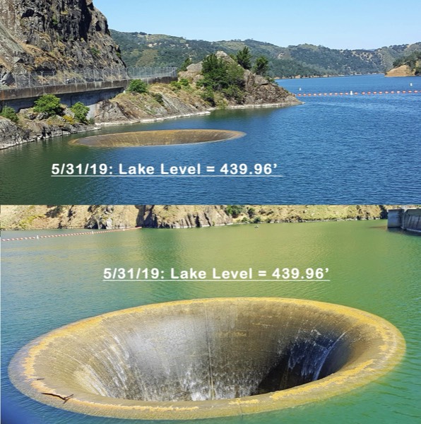
The official SCWA statement echos the potential, "As it sits right now this season will be the closest the lake has ever been to spilling without officially going over. Some of the other years that had low level spills was 2000 with a spill level of 440.33 ft, 1966 with a spill level of 440.47, and 1963 with a spill level of 440.57 ft."
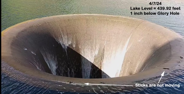
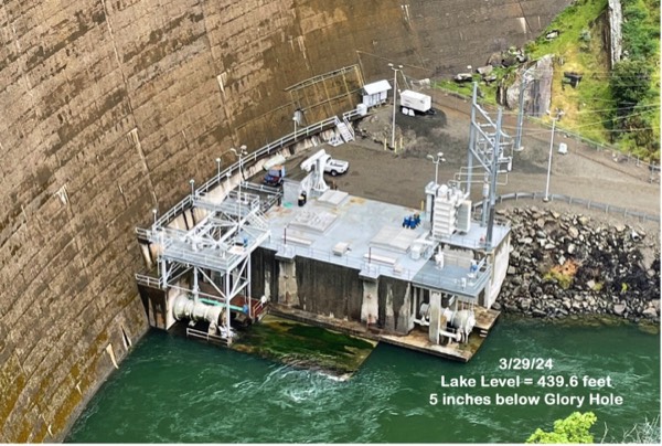
The data from Morning Glory Spillway levels are averaged to hourly and daily values. The maximum hourly averaged value was on 4/5/2024 at 8:00pm and was 439.945 ft. This level only lasted for the one hour, all other datapoints were at lower elevations.
The highest daily averaged value was also on the same day 4/5/2024 and was 439.93 ft. In order for an official spill notification there needs to be enough flow into the spillway to calculate acre-ft/day. There has been no measurable flow into the spillway. Therefore, Glory Hole has not “officially” spilled.
There has been some confusion on social media due to ‘spikes’ in the data that have gone as high as 440 ft, but these were all 15 minute instantaneous values. The instantaneous values have never been an issue until this year due to how close the lake has been to spilling for almost two weeks. Much of that time the level has been a half inch away from the crest. The Solano County Water Agency will be changing their web pages to hourly averages for next season so that these minor blips don't confuse the situation in the future.
Unless we get some wet storms soon the Lake Berryessa will slowly start to recede as the warm weather starts and the agricultural season gets going. Hopefully we get another wet winter next year to fill the lake again, and if we get lucky see the spillway going like we did in 2019! Until then we can all have a great summer enjoying our full lake!
There have also been questions about the water being released from the Monticello Dam. During most of the year the only water released from the dam is what is ordered by the cities and farmers of Solano County, as well as providing required environmental flows to Putah Creek. The only exception to this is when the lake level is above 438 ft and has a likely chance of spilling.
At these higher levels the operators are given some flexibility with releases to help maximize the beneficial use of every drop of water that enters the lake as long as these additional releases never go above the inflow to the lake. It is also much better to maintain controlled releases through a dam rather than allow uncontrolled spilling and losing some of the additional benefits that could be utilized from this water.
This season is a perfect example of how this flexibility is meant to be used. When it was determined a spill was likely, some additional releases were made to comply with the mandated spring pulse flow for Putah Creek which is designed to help flush the salmon fry from this seasons spawn out to the ocean. These pulse flows also provide flushing benefits to other native species in the creek.
After the pulse flow requirements were met the operators then diverted water through the powerhouse at levels below the inflow to the lake so that power could be generated with the “extra” water rather than letting it run through the spillway which bypasses this opportunity for clean power. When the powerhouse is operating all the flow is diverted through the turbines and is output below the concrete pad which is below the water surface. There is no indication it is running unless you look very closely and notice the turbulence from under the pad. This season has been a perfect example of how a dam should be operated.
No matter how you look at it, we officially have a full lake which is still not "officially" spilling. In my biased opinion it is one of the most beautiful lakes in California - see you all on the water!!
Jay Cuetara
Supervising Water Resources Engineer
Solano County Water Agency
CALIFORNIA DATA EXCHANGE CENTER
https://cdec.water.ca.gov/dynamicapp/selectQuery?Stations=BER&SensorNums=6&dur_code=D&Start=2024-03-11&End=2024-04-11
Glory Hole Watch 2024: By the Numbers
by Peter Kilkus
But what are the numbers?
Lake area in acres (to 1 acre); lake level in inches (to 0.01 inch); lake depth in feet (to an average of 1 foot); lake volume in acre-feet (to 1 acre-foot average, varying by depth), lake input in cubic feet per second or acre-feet; lake output in cubic feet per second (to 5%) or acre-feet (to 1 acre-foot); lake evaporation in inches (to 0.01 inch); rainfall in inches (to 0.01 inch). Some are big numbers, some are small numbers, some are tiny numbers, and some are really just estimates (aka guesses). These numbers all interact to produce a final result.
Precision and accuracy are often used interchangeably, but in science they have very different meanings. Measurements that are close to the known value are said to be accurate, whereas measurements that are close to each other are said to be precise. So, a good machine may measure precisely to a half inch every time it takes a lake level reading, but if the calibration point is off in accuracy by one foot, what does it matter? The ideal situation is when the measurement is both accurate and precise.
But the accuracy of any measurement relies on how the measurement is made - and all measurements have some level of variability. Variability is the tendency of the measurement process to produce slightly different measurements on the same test item, where conditions of measurement are either stable or vary over time, temperature, operators, etc. Short-term variability is ascribed to the precision of the instrument. Since most of the survey measurements on which Lake Berryessa data depends were performed in the 1950s with good optical equipment but in rough, irregular terrain, how variable in accuracy was the final data set - what was the level of the statistical standard deviations of the fundamental measurement results?
The following report is meant to explain some of the issues regarding the quickly changing status of the Glory Hole Watch 2024. Is it spilling, flowing or, as some folks have proposed, just drooling over the lip. As of 4/8/24 it seems the lake is full but not yet spilling, and may not officially spill this year. That would be a new historical record - the highest the lake level has ever reached without actually "flowing" over Glory Hole. Our Lake Berryessa News introduction photo shows the results of all the elements of the Glory Hole actually flowing.
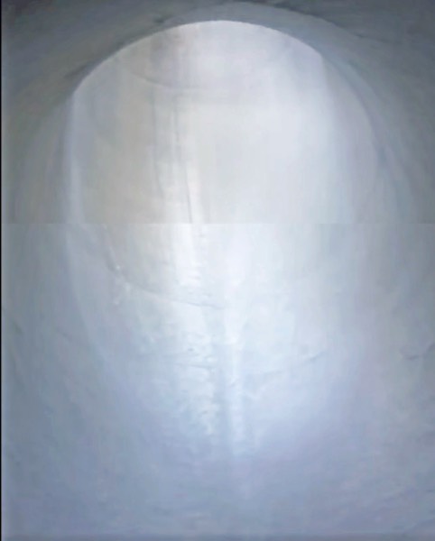
See the recent video of the Glory Hole from inside at the bottom of concrete tunnel. The amount of water coming down is so small that it cannot be measured.
See water spilling into Glory Hole from inside at the bottom.
Jay Cuetara, Supervising Water Resources Engineer
Solano County Water Agency
jcuetara@scwa2.com
_____________________________________
_____________________________________
Glory Hole Video at 439.88 feet
Only 1.4 inches to go
____________________________________________________________
___________________________________________

_________________________________________
*********
Spring 2017 at Lake Berryessa, It's A Beautiful Day - Lake
Berryessa News Drone Report
https://youtu.be/1TVX9Euix3E?si=SYVEO7Ybez2TX2G9
Extended cut:
https://youtu.be/EsqA9DKVeUg?si=HXgodyB2E1jEXS5z
*********
Camping and Marina info FYI...
Steele Canyon Campground:
www.CampSteeleCanyon.com
Pleasure Cove Marina:
www.GoBerryessa.com
Spanish Flat Recreation Area:
campspot.com/park/spanish-flat-campground
Putah Canyon Rec Area:
royalelkparkmanagement.com/putah-canyon
Markley Cove:
www.MarkleyCoveResort.com
Lake Berryessa Boat & Jet Ski
Rental:
www.LakeBerryessaBoats.com
___________________________________________________
___________________________________________________

BUILD YOUR DREAM LAKE HOME!
Lake Berryessa: https://lakeberryessaland.com/
AMBER PAYNE REALTOR
office:707-235-1124, fax:888-864-4133,
email:amber.payne@corcorangl.com, dre#:01302244
1070 Westridge Drive
APN# 019-492-010 • .21 Acre
Offered at $75,000
Flat then downslope
1102 Arroyo Grande Drive
APN# 019-461-025 • .32 Acre
Offered at $27,999
Flat then upslope
259 Sugarloaf Drive
APN#' 019-322-004 • .37+-Acre
Offered at $75,000
Spanish Flat Woodlands
1013 Arroyo Lindo Court
APN# 019-441-004 • .224+· Acre
Offered at $89,500
Mostly flat then upslope.
1268 Steele Canyon Road
APN# 019- 432-001 • .21+. Acre
Offered at $70,000
Flat Space with a hill at back
817 Bahia Vista Court
APN# 019-451-012 • .28+ Acre
Offered at $37,500
Flat downslope, canyon views
814 Bahia Vista Court lot
APN# 019-452-004 • .32 Acre
Offered at $49,000
Mostly flat then downslope
1121 Steele Canyon Road
APN# 019-442-004 • .31+· Acre
Offered at $33,000
Flat then downslope
1075 Rimrock Drive
APN# 019-362-025 • .42+- Acre
Offered at $105,000
Lake View Lot
272 Sugarloaf Drive
APN# 019-321-008 • .25+-Acre
Offered at $45,000
Downslope Lot
1103 Westridge Drive
APN# 019-491-011 • .29+- Acre
Offered at $60,000
Flat Then Downslope Lot
135 Poppy Lane
APN# 019-362-015 • .86+- Acre
Offered at $225,000
Three Lake View Lots To Be Sold Together
1005 Eastridge Drive
APN# 019-484-003 • .18+- Acre
Offered at $42,500
Mostly Flat Then Downslope
1111 Westridge Drive
APN #019-501-001 • .36 Acre
Lake Views, Flat Then Downslope
Live Oak Ln. #21
APN #019-331-008 • .47+ Acre
Offered at $54,000
Extra large lot.
APN#019-570-010
10+ Acres
Offered at $50,000
Undeveloped lot
______________________________________________________________

___________________________________________________

______________________________________________________________
______________________________________________________________
meter.me is the all-in-one rural water monitoring and automation platform that sends real-time data
from your water system to your smartphone and aids in fire preparedness.
With meter.me, you can:
- Remotely monitor tanks, wells, ponds, and water meters.
- Get notified if you have a leak
- Seamlessly share water tank level information with fire agencies in case of a fire emergency
Get meter.me and get peace of mind about your water system.To get started, scan the code above or email at info@meter.me.
************************************
If you want to compare weather activity around the lake, go to the following real-time weather stations around the lake. It would be nice to have some web cams.
Local Lake Berryessa Weather Stations (Weather Underground Network)
Lake Berryessa News Headquarters (Above the Berryessa Highlands)
Temperature gauge is non-operational, but all other measurements are accurate. The interesting thing about our location is the high south wind levels at the top of our hill compared to the lower level Berryessa Highlands stations.
https://www.wunderground.com/dashboard/pws/KCANAPA64
Berryessa Highlands (Somewhere in the Berryessa Highlands)
Berryessa Highlands - KCANAPA20
https://www.wunderground.com/dashboard/pws/KCANAPA20
Skiers Cove (Below the Berryessa Highlands)
Skier Cove - KCANAPA228
https://www.wunderground.com/dashboard/pws/KCANAPA228
East Side Road (Across from Big Island)
East Side Road, Lake Berryessa - KCALAKEB2
https://www.wunderground.com/dashboard/pws/KCALAKEB2
Spanish Flat (Near the Spanish Flat Recreation Area)
Roger - KCASPANI1
https://www.wunderground.com/dashboard/pws/KCASPANI1
______________________________________________________
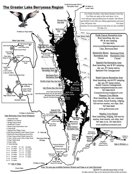
New Lake Berryessa Map Updated 1/28/24
_________________________________________________________________________________
_____________________________________________________________________________________________________
This Book Is Fun To Read!
Thanks to all of you who have bought my new book. I hope you like it. If you have a minute could you please go to the Amazon page for my book, scroll down to the Customer Review section and give it some stars and a good review. I would appreciate it since 5 stars and a good review really help sales.
Although it is not a real moneymaker for me, I would like to sell as many copies as I can so that I don't have to keep answering the same questions over and over on my Lake Berryessa News Facebook page (https://www.facebook.com/profile.php?id=100064928340101), the Lake Berryessa Facebook group (https://www.facebook.com/groups/231107393758315) and other emails. Thanks.
https://www.amazon.com/Lake-Berryessa-Technical-Manual-Engineering-ebook/dp/B0C21DZ9M9/ref=sr_1_3?
************
_________________________________________________________________________________

_____________________________________________________________
Policy and Politics Betray the People: The Lake Berryessa Saga: 1958 - 2020
https://www.amazon.com/Policy-Politics-Betray-People-Berryessa-ebook/dp/B08MFSQDBR/ref=sr_1_1?dchild=1&keywords=peter+kilkus&qid=1604774826&sr=8-1

The KPIX Eye on the Bay interview below is one I did in 2010 and a relevant introduction to the substance of the book. I did it after Pensus had been given the contract for 5 resorts. As we all know Pensus was subsequently kicked out in 2012.

_______________________________________________________________________________________
___________________________________________________________________________________
Lake Berryessa Data Sources
There are many sources of Lake Berryessa water and weather conditions available. The Solano County Water Agency site is good for real-time graphs of level, capacity, and water temperature. The California Data Exchange Center has data going back decades for level, capacity, capacity change, dam outflow, dam inflow, and rainfall. Anyone can research their own data and create custom charts. This is the source of many of the charts on the Lake Berryessa News website.
********
An upgraded wildfire alert camera system will be keeping watch on Napa County day and night and notifying Cal Fire crews of potential fires. Twenty cameras will be part of a system that will use artificial intelligence and other technologies to identify fire and smoke. If they detect something, an alert will sound in the Cal Fire emergency command center near St. Helena.
Cal Fire has made a large investment into the ALERTCalifornia system, partnering with UC San Diego. There are 1,000 cameras across the state and Napa County is one of the test models. Cameras can see 60 miles during the day, and this can increase to 120 miles on clear nights, with the changes in the air. The system can differentiate among smoke, clouds and dust. A link to this camera system and other relevant weather data is available on the Lake Berryessa News website at: http://www.rntl.net/lake-berryessa-cams/
This website was created by Doug Kunst. It is an amazing resource for Lake Berryessa fire cameras and weather. His business website is http://www.rntl.net/
Lake Berryessa Fire Alert Cameras
http://www.rntl.net/lake-berryessa-cams/
********
Real-Time Lake Level, Lake Capacity, Water Temperature
Solano County Water Agency
https://www.scwamonitoring.com/LakeBerryessa/
*********
Lake Detailed Historical Data
California Data Exchange Center
https://cdec.water.ca.gov/
Research historical data and create custom plots
Lake Berryessa Code: BER
https://cdec.water.ca.gov/dynamicapp/sensorplots?staid=ber&dur_code=D
******
Local Weather Stations (Weather Underground Network)
Berryessa Highlands (Somewhere in the Berryessa Highlands)
Berryessa Highlands - KCANAPA20
https://www.wunderground.com/dashboard/pws/KCANAPA20
Skiers Cove (Below the Berryessa Highlands)
Skier Cove - KCANAPA228
https://www.wunderground.com/dashboard/pws/KCANAPA228
East Side Road (Across from Big Island)
East Side Road, Lake Berryessa - KCALAKEB2
https://www.wunderground.com/dashboard/pws/KCALAKEB2
Spanish Flat (Near the Spanish Flat Recreation Area)
Roger - KCASPANI1
https://www.wunderground.com/dashboard/pws/KCASPANI1